Administrative boundaries and postal codes
The contents of the administrative boundaries map
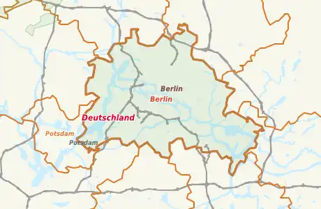
In the map of the administrative borders, we represent the global coverage of administrative regions from the OSM data. These range from country borders on counties to municipalities and individual districts. Also the zip codes are switchable.
About a fold selection bar to the left of the map the respective administrative hierarchies or administrative units can be selected via checkboxes. After selection they are shown in the map worldwide.
The more you zoom into the map, the more details and information will be displayed. The distribution of the respective administrative regions is at any time visible over colored areas on the world map and allows an overview of the world's existing data and the existing gaps.
Descending the administrative boundaries are shown as red to yellow. Districts are highlighted in green.
Remember clippings and share them
You can save map sections with the bookmark function of your browser. Here, the map section and all selected POIs and geometries are stored.
You can also easily copy and save the current browser line (URL). The link thus produced can be send to someone. After clicking on this Link the map will open then as you have set it with the switchable POIs.
Change and supplement data
Clicking the right mouse button on the map opens a context menu. From this menu, you can select an editor for OSM, where then the selected map section is opened for editing.
To edit you need a benevolent OSM account, you can create at any time for free.
By using the menu, it is also possible to display an aerial view of the current section.